|
|
| Stoke-on-Trent Districts: Lane End |
![]()
Next: Maps on Lane End and Longton
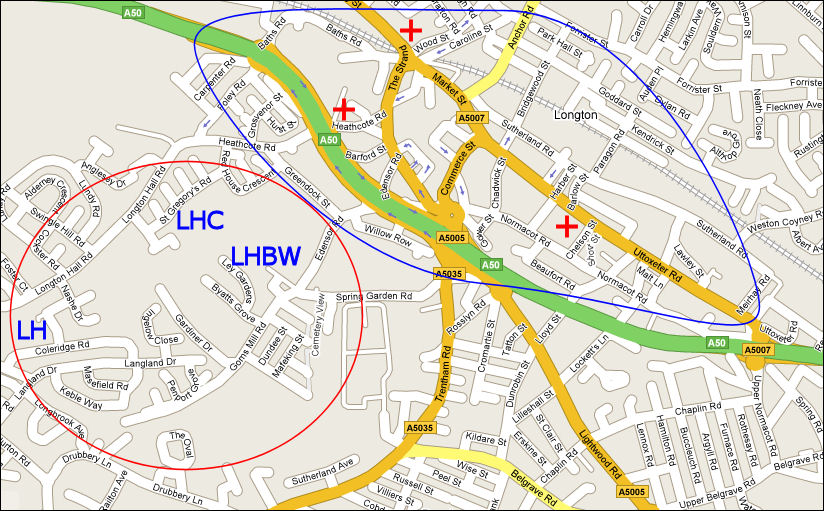
Location of Lane End and Longton..........

Current Map showing the location of
Lane End (blue area) and Longton (red area)
LH = Longton Hall; LHC = Longton Hall Colliery; LHBW =
Longton Hall Brick Works
+ by Wood
Street was the site of St. John's Church of England church.
![]()
+ by Chelson
Street is the site of St. James' Church of England church.
![]()
+ by
Heathcote Road Street was the site of the Roman Catholic church.
Lane End and Longton were two separate townships
|
Lane End, Longton, Stoke-on-Trent, Staffordshire. Confusion often arises over the location and names of Lane End and Longton. Originally they were two separate and contiguous townships which were incorporated in the of Borough of Longton in 1865. Longton was adjacent to Longton Hall and encompassed the Longton Hall Colliery and Brickworks. Even in 1900 the area was mainly fields. Lane End was centred on the area around Market Street and the bottom part of Anchor Road and contained the Markets, Churches and main potworks. The change in name from Lane End to Longton....... "the chief part of the town is in the manor of Longton, although, until about ten years ago, the town was popularly called Lane-End...... The population of Longton in 1841 was 10,393, and Lane-End, 1,952" - 1851 Gazetteer. As with many districts the name and boundaries change over time. Originally Longton and Lane End were two separate locations. Lane End originally called either Mere Lane End or Th'Lone End. The William White gazetteer of 1851 indicates that around 1840 the name changed so the whole of the industrial part of the district lost the name Lane End started to be included in Longton . This is confirmed by John Ward in his 1843 book "The Borough of Stoke-upon-Trent" where he records his distain for the name "Lane End".........
Gazetteer entries for Lane End
|
questions / comments / contributions? email: Steve Birks
15 November 2007